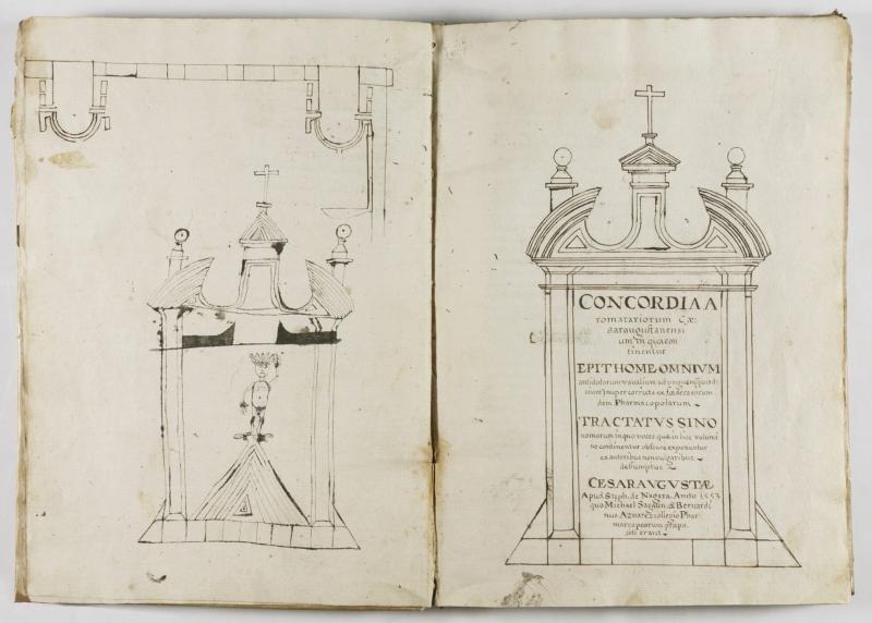
[Sagaun, Miguel; Bernardino Aznares]. Concordia aromatariorum Caesaraugustanensium [UNIQUE MANUSCRIPT COPY OF ONE OF THE EARLIEST KNOWN PHARMACOPEIAS]
[Spain] 1651. Manuscript. Large quarto (28 by 20 cm). Manuscript in brown ink. [4 (Sirup Regis Philippi; copy of title page; title page; blank)], [12 (Ad lectorem; Divisio libri; Carmina in laudem operis; Tractatus de po[n]derib[us] et mensuris; Declaracio[n] de los simples de Mesue)], [3]-177 (Epithome omnium antidotoru[m]; [Tractatus synonomorum]; Tractatus in quo precia omnium medicamentoru[m] simpliciu[m])...; Index antidotoru[m]), [5 (Index continued), [2 (addition recipes)] pp. Title within architectural frame (frame playfully copied by a somewhat later hand on the facing page with additional ornamentation. Contemporary vellum; manuscript title at spine (faded). Text in Latin and Spanish (Introducion; Los Simples de Mesue). Written throughout in a neat hand in brown ink. Due to the different quality of the paper, some quires are more tanned and foxed, and the ink ghosts stronger. Some staining and smudging throughout (but not obscuring text). Few leaves unevenly trimmed at the edges or corners. Page 75 with closed tear at lower gutter and inner margin, not affecting the text. A good or better copy on crisp paper.
Unique manuscript copy of a 16th-century Spanish pharmacopeia. The present manuscript and a single surviving printed edition (Biblioteca de la Real Academia de Farmacia de Madrid) are the only early modern witnesses of this version of the text. One of the first pharmacopeias in the world, (preceded only by Florence and Barcelona), Concordia aromatariorum Caesaragustanensium, was printed at Zaragoza in 1553 by Stephen de Nagera (Esteban Godinez de Nájera) (Haebler, 1897) and is regarded as a revised and much expanded second edition of the 1546 Concordia aromatariorum ciuitatis Cesarauguste, printed by Pedro Bernuz and Bartolomé de Nájera. Besides the variant titles and authors (1546: Jerónimo Assín Mayor with Bernardino Aznares; 1553: Miguel Sagaun with Bernardino Aznares), the two works differ significantly in both structure and content, as well as in the terminolgy used for the various substances. Apart from a revised guide to pricing, the 1553 edition also includes a chapter on simple aromatics written in Spanish verse after Mesue ([Declaracion de] Los simples de Mesué), and a 10-page treatise on synonyms (Tractatus Synonomorum), in which a significant number of words appear in vulgar dialects, along with references to the classic works where they are cited, and guidance for the apothecary to substitute certain products with others to produce the same pharmacological effect. (Francés Causapé 2001, p. 17) (Devaux Guy, 2010). While the 1546 Concordia describes 248 formulations, the 1553 edition almost doubles this number to 447, and for the first time in pharmaceutical literature, classifies formulas containing opium as narcotics (stupefacentibus). (Blasco Nogués 2001, p. 7).
Both Concordias are written in Latin (except for the Introduction and the aforementioned chapter on simple aromatics in the 1553 edition). They are based on the Galenic and Arabic traditions, the latter derived fundamentally from the works of Mesue (Yuhanna ibn Masawaih, ca. 777–857 , an Assyrian scholar and physician from the House of Gundishapur, one of the Sassanian centres of education). Other important influences include the medieval and Renaissance teachings of the Schools of Salerno and Montpellier, along with the French physician Guy de Chauliac, and the Italian surgeon Giovanni da Vigo. In the 1553 edition, the influence of the medical schools of Padua, Bologna, and Ferrara, along with the apothecary Giovanni Giacomo Manlio di Bosco, can be seen as well. (Devaux 2010) (Francés Causapé 2012). Written by Miguel Sagaun, then President of the Colegio de Boticarios de Zaragoza (College of Apothecaries of Zaragoza), and Bernardino Aznares (who collaborated in the writing of the earlier edition), the only known copy of the 1553 edition is held at the Biblioteca de la Real Academia de Farmacia de Madrid. It comprises a title page, a dedication to the reader (Ad lectorem) which explains the three main parts of the book, followed by a treatise on weights and measures (Tractatus de ponderibus & mensuris), an introduction in Spanish (Introducion), and the “declaration of the simples of Mesue” ([Declaracion de] Los simples de Mesué), a description of simple medical substances in Spanish verse in the genre of the Salerno School. The main text begins with the first part introduced in the Ad lectorem on antidotes (De Antidotis), divided into fifteen classes (pp. [3]-165 in our manuscript); the doses are indicated at the right margin, and many synonyms are inserted at the left, along with occasional explanatory notes. The remaining sections comprise the treatise on synonyms (Tractatus Synonomorum); the price list (Tarifa); and an Index. Our manuscript follows essentially the text and layout characteristics of the 1553 printed edition. Notably, the introduction to the price list (Tractatus in quo precia omnium medicamentorum...) is included, but the listing itself has been omitted. In addition, six extra formulations that could not be found in the printed edition are included, of which two are merged into the text, Pulb[is] hiere sim. Galeni on. pp. 56–57, and Unguentu[m] pleureticu[m] Mesue Cap. de aqua cicerum on. p. 147, and four written on the first (Sirup Regis Philippi)) and the last leaves (Ung. Cometisse […]; [unnamed]; Ung. Magistralis). The synonyms indicated on the left margins differ in places from the printed edition, some newly added to the manuscript, and some cancelled (just like the outdated price list). The closing Index here, unlike that in the only known printed copy (with major tear and gaps), appears to be complete. The dated colophon (1651) appears on p. 175, at the close of the treatise on synonyms.
Provenance and annotations: Pascual Savall’s bookplate on inner front panel. The title written in pencil on the inner front panel in a later hand. A later sheet with bibliographical notes (Sanchez’s Bibliografia Aragonesa) mounted on the second free endpaper. Amended with several old, but somewhat later marginal notes in ink by another neat hand. Extra formulations written on the recto of the first leaf, and three more on the last leaf by a contemporary (probably the same) hand. This copy is mentioned in Dionisio Hidalgo’s Boletín bibliográfico español under no. 936 (Hidalgo 1864). Hidalgo claims that the printed book must have been extremely rare already in the 17th century, which is the reason for the existence of this manuscript of 1651. At the end of the entry, Hidalgo refers to the present copy, from “Biblioteca de D. Pascual Savall, en Zaragoza”, apparently Pascual Savall y Dronda, prosecutor (teniente fiscal) at the Zaragoza Court, (co)author of books on the legal history of Aragon and Zaragoza, and an eminent collector of books and manuscripts.
Sachgebiete: Handschriften, Medizin, Mittelalter, Pharmazie, Spanien
31.07.2026 - 23:52
35000,- EUR
Eric Chaim Kline Bookseller
.jpg)
.jpg)